Mavic 3T on the Coastline: A Field Report from Urban Edge
Mavic 3T on the Coastline: A Field Report from Urban Edge Operations
META: Expert field report on using the DJI Mavic 3T for urban coastline missions, covering thermal workflow, O3 transmission, AES-256 security, pre-flight cleaning, and practical mapping considerations.
Urban coastline work looks simple from the promenade. It rarely is from the pilot position.
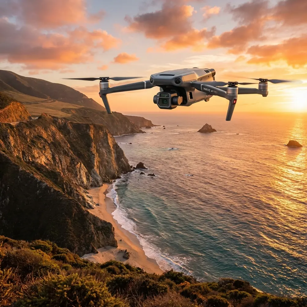
Salt hangs in the air. Wind curls around towers and cranes. Reflections off water can fool visual judgment, while concrete seawalls, marinas, roofs, and pedestrian traffic compress a lot of operational complexity into a narrow strip of airspace. This is exactly the kind of environment where the Mavic 3T starts to make sense—not as a general-purpose drone with a thermal camera attached, but as a compact aerial tool that can switch between inspection, thermal confirmation, and site documentation without forcing the crew to change platforms.
I’ve used larger aircraft for port and shoreline work, and I still respect what those systems can do. But for urban coastline delivery operations, facility checks, roofline-to-waterfront inspections, and time-sensitive municipal work, the Mavic 3T occupies a very practical middle ground. It is portable enough to launch from a constrained urban staging point, yet sophisticated enough to handle missions where visual and thermal context need to be captured in the same sortie.
This field report is built around that real-world scenario: delivering results along coastlines in cities, where the job is usually not “fly and take a look,” but “collect evidence, maintain control, and come home with usable data.”
The pre-flight step many crews rush past
Before batteries, before route review, before lens checks, I always come back to one small habit in salt-air environments: cleaning the aircraft’s safety-relevant surfaces.
That means more than wiping the camera glass. On the Mavic 3T, a proper pre-flight cleaning step should include the vision sensors, obstacle sensing windows, landing sensors, and the airframe surfaces around them. A fine film of salt or grime can build faster than many crews expect near the sea. If those surfaces are dirty, your safety features are working with compromised input.
On an urban coast, that matters. You may be launching between buildings, recovering from a narrow service road, or operating near railings, light poles, facade edges, and mast hardware. Obstacle sensing is not a substitute for piloting skill, but it is still a critical layer of risk management. Letting salt haze sit on those sensors is one of those small oversights that can quietly degrade the very systems you rely on when wind shifts or spatial awareness gets compressed.
I also pay close attention to the thermal lens and visible camera optics after any shoreline session. Salt residue is not just a cosmetic issue; it affects image clarity and can reduce confidence in what you think you’re seeing. If your task is to identify a thermal signature on a building edge, utility enclosure, rooftop vent, or shoreline drainage outlet, image quality is operational quality.
Why the Mavic 3T fits urban coastlines so well
The Mavic 3T is one of those aircraft that proves its value in mixed-task missions. That is the core advantage.
On coastline jobs, the client rarely wants a single data type. They want a thermal sweep of suspect assets, visible imagery for reporting, positional awareness around structures, and enough confidence in the link to work safely from less-than-perfect staging points. The Mavic 3T brings that together in one foldable airframe.
The thermal camera changes the tempo of inspection. You can scan seawall transitions, rooftop edges facing the water, HVAC clusters in coastal commercial buildings, marina electrical infrastructure, or moisture-prone areas where thermal contrast reveals abnormalities not obvious in RGB. Thermal is not magic, and it still depends on environmental interpretation, but it shortens the path to finding the areas that deserve closer attention.
Then there is the transmission side. DJI’s O3 transmission matters more on urban waterfronts than spec sheets suggest. Coastline operations often look open from a map, yet they are full of RF complications: buildings, vessels, cranes, steel structures, and reflective surfaces. A robust live link is not just about pilot convenience. It affects framing, inspection confidence, thermal interpretation, and crew coordination. When you are trying to hold a safe standoff near a facade while also checking a suspected heat anomaly, clean transmission becomes part of mission quality.
Security also deserves more attention than it usually gets in drone discussions. AES-256 encryption is not a decorative feature in commercial work. In urban environments, especially around infrastructure, utilities, transport nodes, and commercial shoreline assets, the protection of transmitted data matters. Clients are increasingly aware of data handling, and secure transmission supports that expectation. For contractors, it also helps when internal compliance teams start asking tougher questions about aerial data workflows.
Thermal is only useful if you read the environment correctly
Urban coastal thermography rewards discipline and punishes assumptions.
Water moderates temperature differently from concrete. Metal railings can heat quickly. Wet surfaces can distort apparent thermal patterns. Shade lines move fast around towers. Wind off the water changes the cooling behavior of facades, rooftops, and exposed equipment. The Mavic 3T gives you thermal visibility, but interpretation still belongs to the operator.
That is why I treat thermal scans along the coast as a layered process.
First, perform a broad thermal sweep to identify outliers. Second, cross-check with the visible feed. Third, adjust angle and altitude to confirm whether the hotspot is persistent or simply a reflection-related artifact or environmental effect. This is where the dual utility of the Mavic 3T becomes practical rather than theoretical. You are not switching systems or landing to reconfigure. You are resolving uncertainty inside the same mission window.
A good example is drainage and moisture tracking along urban waterfront structures. A wall face might look visually intact from the promenade, yet a thermal pass can reveal temperature variation tied to trapped moisture, seepage routes, or insulation irregularities. That does not replace a structural assessment, but it gives engineers and maintenance teams a faster path to the right problem area.
The same applies to rooftop and facade transitions on coast-facing buildings. Salt exposure, wind-driven rain, and thermal cycling create failure points that often begin subtly. The Mavic 3T helps crews locate those early clues with less disruption than traditional access methods.
Mapping around the shoreline: where photogrammetry needs realism
People often ask whether the Mavic 3T can cover photogrammetry tasks in these environments. The short answer is yes, with caveats.
Urban coastlines are not ideal mapping territory. Water surfaces are notoriously poor for reconstruction. Repetitive textures on seawalls and piers can challenge clean model generation. Tidal change alters the scene. Moving boats, pedestrians, and wave action introduce inconsistency. If the objective is high-confidence measurement or repeatable shoreline documentation, your planning discipline matters more than the marketing term.
This is where GCP workflow becomes relevant. Ground Control Points are still one of the smartest ways to anchor a demanding coastal mapping job. If you are documenting revetments, retaining walls, construction interfaces, drainage paths, or urban flood-mitigation features, GCPs can improve trust in the final deliverable. Without them, your model may still be visually useful, but accuracy expectations should be managed.
I would not choose the Mavic 3T as a pure mapping-first aircraft over every other option, but that misses the point. Its value is in combined missions. You can document a coastline asset visually, run a thermal pass for defect screening, and still collect enough structured imagery for site context and surface reconstruction where conditions allow. For councils, engineering teams, and shoreline contractors, that all-in-one flexibility often matters more than single-metric perfection.
Battery planning near the sea is a bigger deal than many teams admit
Coastal wind reshapes battery strategy.
Even when conditions feel manageable at takeoff, headwinds on return can consume reserve faster than expected. Add urban turbulence around buildings, and your flight profile may become less efficient than the route planner suggested. That is why battery discipline on Mavic 3T missions has to be conservative near the shoreline.
If your team uses hot-swap batteries as part of a rotation workflow, the operational benefit is simple: reduced downtime and more continuity during time-sensitive inspections. That matters when tide, traffic windows, site access, or changing light are part of the mission. You can keep the job moving without losing the rhythm of the inspection.
But the real value is not speed for its own sake. It is consistency. The longer a team waits between flights, the more environmental conditions shift. On a coast, that can mean changing thermal contrast, stronger wind, moving shadows, and more pedestrian interference. Tight turnaround helps preserve comparability across sorties.
My rule is straightforward: plan the return leg as if the wind will be less forgiving than it looks. On a coastline, it often is.
BVLOS talk belongs in the planning room, not as a casual ambition
The term BVLOS gets thrown around too loosely. For coastline work, I understand why people bring it up. Long linear assets seem like natural candidates for extended corridor operations. But in urban areas, that discussion has to stay inside legal, procedural, and safety boundaries.
What matters here is not romanticizing distance. It is building operations that scale responsibly.
The Mavic 3T can support professional-grade mission planning and data capture in complex edge environments, but urban shoreline work still demands disciplined airspace review, observer strategy where required, communications planning, and clear geospatial awareness. If a project eventually moves toward approved advanced operations, that should happen through proper regulatory pathways, not because the coastline “looks open enough.”
What clients actually notice in the final deliverable
Most clients do not care about drone jargon. They care that the report is clear, the imagery is trustworthy, and the findings help them make decisions.
With the Mavic 3T, the strongest deliverables usually combine three things:
- A visible overview showing the asset in context
- Thermal frames that isolate suspect zones
- Commentary that explains whether the anomaly is likely meaningful or just environmental noise
That third part is where professionals separate themselves. A thermal image without interpretation is often just an attractive color palette. If you explain that a heat variation was checked from multiple angles, cross-referenced with visible imagery, and observed under sea-breeze conditions that may affect surface cooling, your client gains confidence in the result.
Urban coastline stakeholders also respond well to repeatability. If you can establish the same launch point, similar angles, and consistent inspection routes over time, the Mavic 3T becomes a monitoring tool rather than a one-off camera platform.
A practical note on communications and job flow
When crews are coordinating fast-moving shoreline work—especially with contractors, property managers, or marine-adjacent facility teams—response time matters. If you need to line up a technical discussion before a mission window, this direct project chat link is often the quickest route: message the flight team.
That kind of simple coordination sounds minor, but on urban coastlines, timing affects everything from access permissions to pedestrian density to sun angle to thermal readability.
Where the Mavic 3T earns its place
The Mavic 3T is not defined by one feature. Its real strength is how several features combine in a difficult environment.
Thermal capability helps identify what the eye misses. O3 transmission supports control and image confidence in RF-cluttered waterfront settings. AES-256 encryption adds credibility for commercial data handling. Careful sensor cleaning before flight protects the safety systems you may need most in salt-heavy air. Add disciplined battery rotation, realistic mapping expectations, and a sound understanding of thermal interpretation, and the aircraft becomes much more than a compact drone with a premium badge.
For urban coastline missions, that combination is hard to dismiss.
It gives inspectors, survey teams, facility managers, and infrastructure contractors a platform that can move quickly, gather multiple forms of evidence, and adapt to the messy edge where land, water, weather, and city geometry all meet. That edge is where weak workflows get exposed. It is also where a well-run Mavic 3T operation looks very good.
Ready for your own Mavic 3T? Contact our team for expert consultation.