Mavic 3T for Mountain Wildlife Monitoring
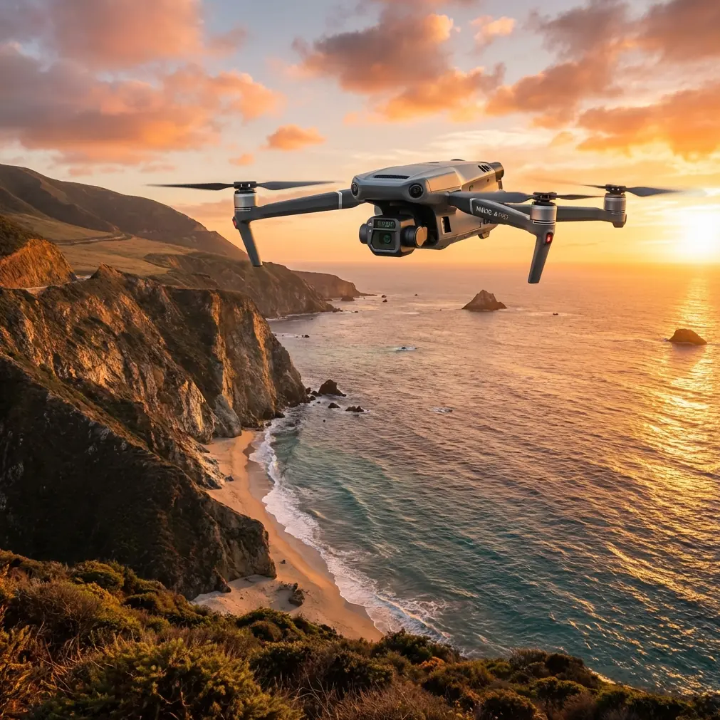
Mavic 3T for Mountain Wildlife Monitoring: What Actually Matters in the Field
META: Expert how-to on using the Mavic 3T for mountain wildlife monitoring, with practical insight on thermal detection, transmission reliability, data security, and why municipal drone workflows matter.
A few winters ago, I was helping a conservation team track animal movement along a steep ridgeline where visual searches kept failing. The problem was not effort. It was terrain, timing, and the simple fact that wildlife does not wait around for a clean line of sight. By the time spotters reached one vantage point, the animals had already crossed into another fold of the mountain.
That experience changed how I think about small thermal drones, and it is why the Mavic 3T deserves serious attention for mountain wildlife work. Not because it is fashionable, and not because every mission needs the same aircraft, but because this class of platform solves a very specific operational problem: finding, verifying, and documenting activity in difficult ground without turning the survey itself into the disturbance.
There is an unexpected clue in a recent civic use case. North Kesteven Council has been using a drone to identify suspected planning breaches, and it is also being used to investigate fly-tipping and help enforce smoke-free zones. On the surface, that sounds far removed from wildlife monitoring. It isn’t. The significance is that local authorities are relying on drone workflows for three different observation tasks: locating signs of change, checking dispersed sites, and gathering usable evidence across varied environments. That same operational pattern maps cleanly onto mountain conservation work. You are not just flying to “look around.” You are using a repeatable aerial method to detect anomalies, revisit them, and support decisions.
For wildlife teams, the Mavic 3T sits in that exact space.
Start with the mission, not the aircraft
When people say they want to use a Mavic 3T for wildlife in the mountains, they often mean one of four different jobs:
- Locating animals by heat before sunrise or after sunset
- Monitoring movement corridors without hiking through them
- Checking nesting or denning zones from stand-off distances
- Building a georeferenced record of habitat conditions over time
Those are not identical tasks. The flight profile, altitude, lens choice, and data handling approach all change. The Mavic 3T becomes valuable when you treat it as a sensor platform rather than a generic drone.
For mountain wildlife, thermal signature is usually the first reason teams consider it. In broken terrain, visible imagery can be deceptive. A deer, goat, or boar can disappear into scrub that looks almost flat from above. Thermal helps separate living subjects from cold rock and shadow. It is not magic. Sun-warmed stone, wet ground, and drifting temperature layers can create false positives. But when used at the right times, thermal cuts search time dramatically.
That is the first major lesson. Don’t ask whether the Mavic 3T can “see animals.” Ask whether the thermal signature will separate cleanly from the background in your conditions.
Why mountain conditions punish weak workflows
A mountain mission exposes every weakness in planning. Wind changes quickly. Line of sight comes and goes. Battery consumption rises during climbing legs and repositioning. The terrain itself makes situational awareness harder for both pilot and observer.
This is where features people mention casually start having real operational significance.
O3 transmission is not just a spec-sheet line
In the mountains, signal reliability matters because ridges and tree cover create abrupt dead zones. A robust O3 transmission link gives the pilot a better chance of maintaining stable control and video feed while working from safe launch points rather than scrambling to follow the aircraft downslope. For wildlife monitoring, that matters for two reasons.
First, a cleaner live feed means better real-time interpretation. If you are searching for a small warm target moving across patchy rock and brush, video breakup can be the difference between a confirmed sighting and a maybe.
Second, reliable transmission supports lower-disturbance operations. Instead of pushing the team physically closer to the habitat, you can often hold a more respectful standoff position and still collect useful imagery.
That does not make every mountain flight suitable for BVLOS operations. Regulatory compliance always comes first. But even within standard visual line of sight work, stronger transmission gives you more flexibility in complex ground.
Hot-swap batteries change the rhythm of field days
Anyone who has done wildlife surveys in cold highland air knows the hidden killer is not just total endurance. It is momentum. You find a window when thermal contrast is ideal, and then you lose it while the team fumbles through battery handling, restarts, or repositioning.
Hot-swap batteries matter because they shorten that dead time between sorties. In mountain wildlife work, the useful observation window can be narrow: dawn emergence, dusk return, or a brief period when sun loading has not yet contaminated the thermal scene. If battery changes are clumsy, you miss the best part of the mission.
This is especially relevant when trying to build repeatable transects. Fast turnaround lets you fly adjacent sectors in sequence while conditions remain comparable. That gives cleaner data later when you are reviewing changes in movement or density.
Thermal is only half the story
The Mavic 3T becomes much more useful when teams stop treating thermal and visual capture as separate missions. In the field, thermal finds. Visual verifies.
A warm spot on a scree slope might be an animal, a person, or sun-retained rock. Thermal gets your attention there. The visual payload helps classify what you are seeing and document the surrounding habitat context. That combination is what turns a search tool into a management tool.
For mountain wildlife teams, that can support several practical outcomes:
- Confirming whether an apparent hotspot is wildlife before logging the observation
- Checking whether a corridor is active or blocked by fresh debris or human disturbance
- Comparing animal presence against terrain features such as gullies, ledges, and tree breaks
- Creating reports that non-pilots can understand without needing to interpret raw thermal imagery
This is where photogrammetry also enters the picture. The Mavic 3T is not only about detection. It can support terrain documentation and habitat analysis when flights are planned with overlap and control in mind. If you are mapping a mountain meadow edge, a landslip near a nesting zone, or a recurring crossing point, photogrammetry gives you a repeatable surface record that simple observation notes cannot match.
Use GCPs where practical if you need tighter positional consistency across repeated surveys. In steep ground, even small geospatial discrepancies can make before-and-after comparisons messy. Ground control is not always easy in remote habitats, but when the objective is habitat change analysis rather than quick reconnaissance, it pays off.
The civic enforcement example matters more than it seems
Let’s go back to that council case, because it reveals something useful for wildlife professionals. North Kesteven Council is using a drone for suspected planning breaches, fly-tipping incidents, and smoke-free zone enforcement. Three very different targets. One aerial workflow.
Why does that matter if your reader cares about ibex, deer, or nesting birds rather than civic compliance?
Because the lesson is about versatility under constraints. The same drone workflow can be adapted to detect unauthorized landscape change, locate dumped material, and observe behavior linked to rule compliance. In wildlife management, the pattern is similar:
- detect habitat disturbance
- locate unusual activity
- monitor sensitive zones without repeated physical entry
That overlap is operationally significant. It shows how compact drones are becoming standard tools for field inspection where access is awkward, time matters, and documented evidence is needed. Wildlife teams can borrow that discipline. Fly repeatable routes. Log findings systematically. Keep location-aware records. Build evidence, not anecdotes.
Too many conservation programs still rely on fragmented observation habits when a drone can help standardize the process.
Data security is not an abstract concern
Wildlife location data can be sensitive even in civilian conservation contexts. Nest sites, denning locations, and migration bottlenecks should not be handled casually. That is why data security deserves mention in any Mavic 3T workflow.
AES-256 encryption matters because not all drone data is harmless once it leaves the field tablet. Protected transmission and storage reduce the risk of exposing geotagged information tied to vulnerable species or restricted habitats. This is not paranoia. It is good fieldcraft in a digital era.
I have seen teams do excellent survey work and then undermine it by sharing loosely managed files across personal devices and public apps. If you are monitoring wildlife in remote mountain terrain, think through the full chain: aircraft, controller, export process, cloud policy, archive, and who gets access.
The drone is only one part of the system.
A practical mountain workflow for the Mavic 3T
If I were setting up a Mavic 3T mission for wildlife monitoring in mountain terrain, I would keep the method disciplined.
1. Fly when thermal contrast works in your favor
Pre-dawn and late evening are often the cleanest periods. Midday in rocky terrain can create confusing heat patterns. Don’t waste your best batteries on bad thermal conditions.
2. Define the survey objective before takeoff
Are you counting individuals, checking corridor use, confirming den occupancy, or documenting habitat disturbance? One sortie cannot do all of these well.
3. Build a layered search pattern
Use thermal for broad detection, then tighten the search with visual confirmation. Save exact coordinates only when identification confidence is high.
4. Keep launch points conservative
In mountains, chasing a “better angle” can put the crew in worse terrain and stress the link. Choose stable, safe positions and let the aircraft do the movement.
5. Use repeated routes for trend monitoring
If you want useful comparisons over weeks or seasons, standardize altitude, direction, time window, and overlap. This is where photogrammetry and GCP-supported mapping become more than optional extras.
6. Plan battery rotation around the biological event
Do not start changing packs right when animals typically emerge. Hot-swap efficiency should support the behavior cycle you are targeting.
7. Protect the data
Apply encrypted workflows and access control, especially when the imagery reveals exact habitat locations.
What the material science references quietly tell us
The supporting reference material includes a technical extract on hybrid composites, with figures such as an Ex value of 86.9 GPa for one unidirectional Kevlar49/T300 composite listing and 77.9 GPa in another data point on the same page. At first glance, that looks disconnected from a Mavic 3T article. It is not entirely irrelevant.
The practical takeaway is that modern airframes and payload systems live in a design world shaped by stiffness-to-weight tradeoffs, laminate behavior, and durability under environmental stress. In mountain operations, that matters because a compact aircraft has to stay structurally stable while remaining portable enough to deploy from rough ground. The point is not that a Mavic 3T uses those exact handbook values. It is that the engineering culture behind professional UAVs depends on material performance balancing rigidity, weight, and resilience.
A second reference lists vibration-related aircraft standards and components, including a metal friction damping isolator standard, HB6131-87. Again, this is not a direct product spec for the Mavic 3T, but it highlights a reality every mountain operator understands: vibration control is mission quality control. In windy ridge environments, oscillation and resonance do not just affect comfort. They affect image clarity, thermal interpretation, and mapping consistency. Stable imaging in hostile air is not accidental. It is the result of disciplined mechanical design.
That matters in wildlife work because misreading a blurred thermal target is worse than seeing nothing at all.
The real advantage of the Mavic 3T in wildlife work
The strongest case for the Mavic 3T is not raw capability in isolation. It is how much field friction it removes.
It shortens the gap between detection and verification.
It helps teams work from less intrusive positions.
It supports both thermal search and visual documentation.
It fits into structured inspection-style workflows that councils and field agencies are already proving in other civilian sectors.
That last point deserves emphasis. The North Kesteven example is a sign of drone maturity. When local government trusts a drone to check planning breaches, investigate fly-tipping, and monitor smoke-free compliance, it signals confidence in repeatable aerial observation as a practical public-service tool. Wildlife monitoring in mountain terrain needs that same mindset: planned missions, evidence-grade data, and minimal disturbance.
The Mavic 3T is at its best when used that way.
If your challenge is simply “find animals,” you may underuse it. If your challenge is “detect, verify, map, revisit, and document wildlife activity in difficult terrain,” then it starts to earn its place in the pack.
And if you are trying to design a mountain workflow around that kind of mission, it helps to talk it through with someone who has already learned a few lessons the hard way. You can start the conversation here: message an M3T field specialist
Ready for your own Mavic 3T? Contact our team for expert consultation.